
In order to detect and track tornadoes, forecasters and storm spotters are specially trained to identify storm features that would make tornadoes more likely. Some features are those seen outside such as a rear-flank downdraft (Figure 1), while others are patterns in Doppler radar images, such as the tornadic vortex signature (TVS). Mesocyclones are large rotating updrafts that occur inside a supercell and are another specific feature looked for in Doppler radar data. Finally, the hook echo is another pattern searched for in radar images and is associated with mesosyclones.
Tornado Detection and Tracking
Figure 1. Arrow points to a rear-flank downdraft (Image courtesy of NOAA).
The WSR-88D Mesoscale Detection Algorithm is a program developed by The National Severe Storms Laboratory (NSSL) to analyze Doppler radar data. The program detects rotation patterns that fit the criteria for a mesocyclone and the velocity patterns of the TVS (Figure 2). Mesocyclone detection is useful in predicting tornado potential, while the TVS is a great tool for detecting tornadoes before they touch ground and where they will touch ground, as the TVS appears on the radar several kilometers above the ground before the tornado reaches land. The presence of a TVS does not guarantee a tornado will touch ground, but it does greatly increase the probability (NSSL).

Figure 2. Yellow circle represents a mesocoyclone, red triangle is the TVS. (Image courtesy of NOAA)
A hook echo is detected using radar reflectivity images (Figure 3). This phenomenon looks like a hook coming from the radar echo and is usually found in the right-rear part of the storm, relative to the motion of the storm (NSSL). Hook echoes appear on radar reflectivity images as a result of precipitation wrapping around the backside of the updraft from a rear-flank downdraft.
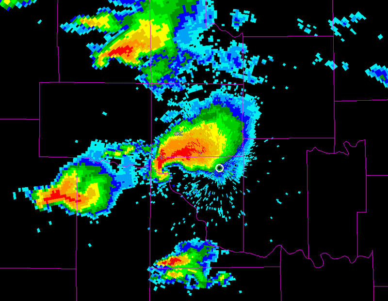
Figure 3. Image of a hook echo courtesy of NOAA.
The National Severe Storms Laboratory is currently working on an improvement to the WSR-88D program. This next-generation program called WDSS-II will use multiple radars and sensors to collect data, allowing for more information and therefore better detecting and forecasting. Presently, NSSL installs Doppler radars on NOAA’s P-3 aircraft to study storms using dual-Doppler from the air as well as ground.